Agents
Table of contents
Displays the locations where agents are currently performing an activity, day plans of single agents.
Requires a loaded network file and an events or population file.
Agents
The Agents layer (named Activities layer in earlier versions of Via) displays a colored dot at each location where an agent is currently performing an activity. Different types of activities can be visualized with different colors. To create an Agents layer, two possibilities exist:
- Load the agent data from events. The location and the start and end time of activities are retrieved from events. The location can only be determined based on the link id, activities are thus always shown at the end of a link. See below for a way to add more exact locations in a second step.
- Load the activity data from population. The location (link id or, if given, the exact coordinate) as well as the start and end time of activities are extracted from a plans file.
Only one of the two sources (events, or population) can be used to create an agents layer. If you want the actual activity times from events, but want to use the exact location as given in a plans file, follow the steps below.
Each activity type can be shown in a different color. To setup the colors, click on the color wheel icon. Then, assign colors to the different activity types. To add a new activity type, click the “+” icon. Note that you can use an asterisk as wildcard character to match multiple, similar activity types and assign them one common color. To learn what activity types actually occur in the data, click on the little gearwheel icon and select Find attributs.... A list of all activity types found in the loaded data will be shown, along with the color in which they would currenctly be displayed.

Please note that the Activities Layer may slow down the visualization enormously if a large number of agents is shown.
Displaying activities at the exact location
When loading data from events, only the link events are available to determine the location of an activity. Thus, all activities are located at the end of links, which may look neither realistic nor nice. As the population file contains the detailed x and y coordinate values, it is possible to load the exact location data from such a file to improve the visualization.
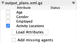
Switch to the Data Sources section and add the population file, if you have not yet done so. The population file will then show some options to load additional attributes from the file, one of them being the activity locations. Select it and click on Load Attributes. Make sure Add missing agents is not checked. After the locations have been loaded, the visualization should refresh and show the activities with the actual locations as specified in the population.
Make sure to use the correct population file, i.e. the population file from the iteration that matches the events file. There will be unexpected results if you mix an events file from e.g. iteration 10 with the initial population file.

